
London is a city best discovered in layers—its Roman roots, Tudor palaces, Victorian grandeur, and modern pulse all coexisting within a short stroll or a scenic bus ride. While the London Underground may be the fastest way to get around, nothing beats the experience of touring the city from the top level of a red double-decker bus. It is even more safer than tube, for example. From the iconic skyline of Westminster to the energetic bustle of Oxford Circus, riding one of London’s classic double-deckers offers a unique and affordable way to explore the capital. Here’s why and how to do it—and what to look for from your elevated perch.
Exploring Oxford Street: London’s Iconic Shopping Artery Aboard the No. 7 Bus
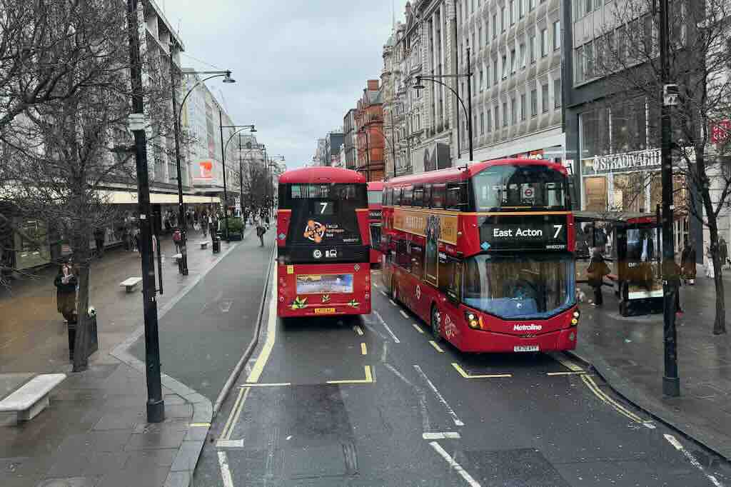
Few urban experiences encapsulate the essence of London quite like a ride on one of its iconic red double-decker buses. The above image I took from the front seat of another bus, from an elevated vantage – capturing two Route 7 buses navigating Oxford Street, one of the most renowned shopping destinations in the world.
On a gray, wintry day typical of London, the red buses provide a striking contrast to the overcast sky and the subdued tones of the surrounding architecture. Route 7, connecting East Acton to Oxford Circus, passes through some of London’s most lively quarters. The bustling street, flanked by famous retailers like Stradivarius and John Lewis (both visible in the photo), pulses with shoppers and commuters. The trees are still leafless because it is late winter time in London.
Practical Travel Information
Location: Oxford Street, London W1D, United Kingdom
Bus Route Featured: Route 7 (East Acton ↔ Oxford Circus)
Transport Tip: The easiest way to explore Oxford Street is with a contactless payment card or an Oyster card. Hop-on-hop-off convenience makes this route ideal for casual sightseeing.
Closest Tube Stations: Oxford Circus (Bakerloo, Victoria, and Central lines), Bond Street (Central and Jubilee lines)
Best Time to Visit: Weekdays before noon for smaller crowds; Christmas season for dazzling lights.


Oxford Street in Motion: Urban Life at Its Peak
This image I took behind the red lights capturing the essence of Oxford Street at peak energy—a brilliant visual synthesis of movement, architecture, and human flow. We were standing once again at an intersection of Oxford Street.
The scene features a signature red double-decker bus, a white utility vehicle, and an Addison Lee cab weaving through heavy pedestrian footfall and complex traffic signals. Niketown London appears on the left, anchoring the image with its commanding neoclassical presence. On the right, the earthy tones of a turreted Edwardian building soften the cold geometry of the modern city.
The crowd density underscores Oxford Street’s role as a commercial and commuter artery—this is where fashionistas, office workers, tourists, and Londoners in transit collide. In this photo you can see how London manages chaos with order: red lights flash in every direction, yet everything seems to function in synchrony.
Tip for Visitors: For a less crowded photo opportunity, try early Sunday mornings or weekday mornings before 10 AM
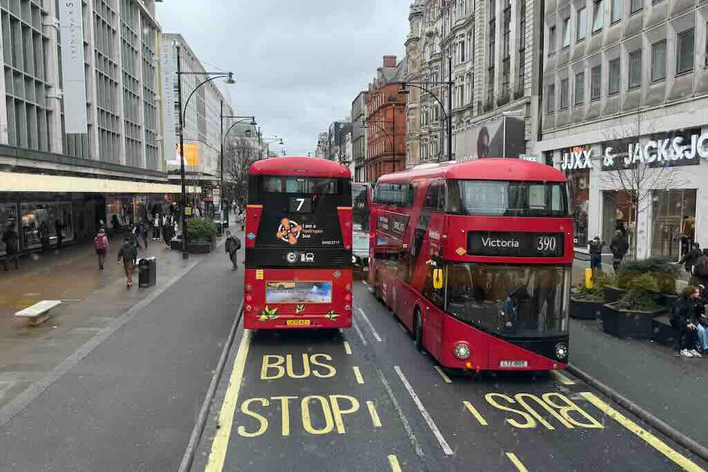
Street-Level at Oxford Circus
In the second photo from the Oxford Street area I captured the kinetic energy of one of London’s busiest intersections. The Underground sign is prominently featured at the Oxford Street Tube station.
Across the street Niketown London reappears; the European flagship of Nike and a magnet for sneakerheads and sportswear fans from around the globe. The building’s neoclassical façade blends seamlessly with the grandeur of its neighboring structures, preserving the district’s early 20th-century charm while housing cutting-edge retail.
The pedestrian traffic is dense and dynamic, with people waiting at crossings, pouring up from the subway, and queueing for access to stores—an embodiment of London’s perpetual motion. The classic red-green pedestrian lights, the “Look Right” pavement markings, and a black Addison Lee taxi all anchor this scene in quintessentially British detail.

What Do the White Zigzag Lines and Road Markings in London Mean?
If you’ve walked or driven through London, you’ve probably noticed white zigzag lines painted near pedestrian crossings, or bold text on the asphalt saying LOOK RIGHT, BUS STOP, or KEEP CLEAR. These aren’t just decorative elements or quirky British habits—they’re critical parts of the city’s traffic management system, designed to keep both drivers and pedestrians safe. Here’s what these road markings mean, why they’re important, and how they help travelers navigate London more safely and confidently. –
1. White Zigzag Lines Near Crosswalks (Zebra Crossings)
What do they mean?
These zigzag lines appear before and after zebra crossings and indicate a strict no parking or stopping zone. The goal is to ensure that drivers approaching a crossing can clearly see pedestrians waiting to cross.
Where are they used?
You’ll see them next to zebra crossings—uncontrolled crosswalks with black-and-white stripes and often a flashing amber Belisha beacon.
Why does it matter?
Parking or stopping within the zigzag area is illegal and can result in fines, especially as many crossings are monitored by traffic cameras.
2. LOOK RIGHT / LOOK LEFT
Why is it written on the street?
In the UK, traffic drives on the left-hand side of the road, which can be confusing for visitors from right-hand traffic countries. These instructions—painted at pedestrian crossings—help ensure people look the correct way before stepping out.
Where will you see it?
Nearly everywhere in Central London with high foot traffic—especially around tourist hotspots like Oxford Street, Trafalgar Square, and Westminster.
Traveler tip:
Even if the road says LOOK RIGHT, always check both directions—some streets are two-way or used by cyclists and buses going against traffic.
3. BUS STOP, KEEP CLEAR, SCHOOL
BUS STOP
Indicates a designated bus stop area. No other vehicles are allowed to park or stop here, even briefly.
KEEP CLEAR
Often found in front of driveways, intersections, or emergency service entrances. It means vehicles should never block that part of the road.
SCHOOL
Marks a school zone—drivers should slow down, watch for children, and expect increased enforcement.
4. Why These Markings Matter to Travelers
- Visual guidance even for those who don’t speak English fluently.
- Enhanced safety in busy urban areas with heavy pedestrian traffic.
- Helps you avoid violations that could lead to fines or dangerous situations.
Traveler tip:
If you’re exploring London by foot or bus, pay attention to these markings—they’re a local language that speaks directly to your safety and experience in the city.
Why Ride a Double-Decker in London?
1. It is Scenic and immersive:
The upper deck provides unmatched views of London’s landmarks and street life. From famous monuments to hidden architectural gems, you’ll see far more than you would underground or on foot.
2. It is budget-friendly sightseeing:
A single bus fare costs just £1.75 with an Oyster card or contactless payment—no matter the distance. You can also transfer between buses for free within an hour thanks to the Hopper fare.
3. It is Convenient and comprehensive:
London’s bus network covers every corner of the city, often following scenic routes the Tube doesn’t. Many routes pass key attractions, neighborhoods, and shopping areas.
Top Routes for Tourists
While nearly any route can surprise you, several are especially scenic or useful for first-time visitors:
- Route 11: From Liverpool Street to Fulham Town Hall, this line passes the Bank of England, St Paul’s Cathedral, Trafalgar Square, and the Houses of Parliament.
- Route 9: Historic sights from Aldwych through Hyde Park and Kensington.
- Route 15: Features heritage Routemaster buses on part of the route (check availability).
- Route 7 & 390: Excellent for exploring Oxford Street, Regent Street, Hyde Park, and Camden.
Practical Tips for the Best Experience
Board smartly:
Enter through the front door, tap your card, and head upstairs quickly for the best seats—front row, top deck.
Travel off-peak:
Try late mornings or early afternoons on weekdays to avoid rush hour and school crowds.
Use the app:
Download the TfL Go app or use Google Maps with public transport mode to plan routes, check arrival times, and navigate changes.
Mind the curves:
London’s narrow streets and tight corners mean you’ll feel every turn on the upper deck—hang on and enjoy the ride.
Stay alert at landmarks:
Use bus stops or upcoming announcements to time your photos. Many buses announce the next stop and highlight nearby attractions.
Accessibility and Sustainability
- Accessible travel: All modern London buses are step-free and equipped with designated areas for wheelchairs and strollers.
- Green fleet: Many buses now run on electric or hydrogen power—like those seen on Route 7—supporting London’s ambitious emissions goals.
Read more travel tips for Europe from my INDIVUE Visual travel guide for Europe!


Leave a comment