
• Above the Crowd: Exploring London from the Top Deck of a Double-Decker Bus

    London is a city best discovered in layers—its Roman roots, Tudor palaces, Victorian grandeur, and modern pulse all coexisting within a short stroll or a scenic bus ride. While the London Underground may be the fastest way to get around, nothing beats the experience of touring the city from the top level of a red double-decker bus. It is even more safer than tube, for example. From the iconic skyline of Westminster to the energetic bustle of Oxford Circus, riding one of London’s classic double-deckers offers a unique and affordable way to explore the capital. Here’s why and how to do it—and what to look for from your elevated perch.
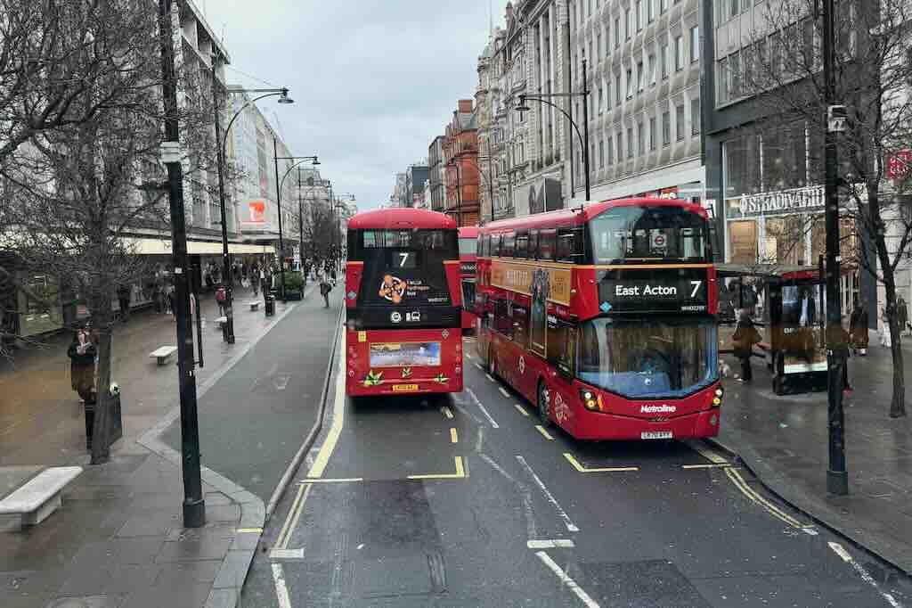
    Double-decker buses in central London
    Double-decker buses in central London

    Exploring Oxford Street: London’s Iconic Shopping Artery Aboard the No. 7 Bus

    Few urban experiences encapsulate the essence of London quite like a ride on one of its iconic red double-decker buses. The above image I took from the front seat of another bus, from an elevated vantage – capturing two Route 7 buses navigating Oxford Street, one of the most renowned shopping destinations in the world.

    On a gray, wintry day typical of London, the red buses provide a striking contrast to the overcast sky and the subdued tones of the surrounding architecture. Route 7, connecting East Acton to Oxford Circus, passes through some of London’s most lively quarters. The bustling street, flanked by famous retailers like Stradivarius and John Lewis (both visible in the photo), pulses with shoppers and commuters. The trees are still leafless because it is late winter time in London.

    Practical Travel Information

    Location: Oxford Street, London W1D, United Kingdom
    Bus Route Featured: Route 7 (East Acton ↔ Oxford Circus)
    Transport Tip: The easiest way to explore Oxford Street is with a contactless payment card or an Oyster card. Hop-on-hop-off convenience makes this route ideal for casual sightseeing.
    Closest Tube Stations: Oxford Circus (Bakerloo, Victoria, and Central lines), Bond Street (Central and Jubilee lines)
    Best Time to Visit: Weekdays before noon for smaller crowds; Christmas season for dazzling lights.

    Oxford Circus in Motion: Urban Life at Its Peak
    Oxford Circus in Motion: Urban Life at Its Peak
    Street-Level at Oxford Circus
    Street-Level at Oxford Street

    Oxford Street in Motion: Urban Life at Its Peak

    This image I took behind the red lights capturing the essence of Oxford Street at peak energy—a brilliant visual synthesis of movement, architecture, and human flow. We were standing once again at an intersection of Oxford Street.

    The scene features a signature red double-decker bus, a white utility vehicle, and an Addison Lee cab weaving through heavy pedestrian footfall and complex traffic signals. Niketown London appears on the left, anchoring the image with its commanding neoclassical presence. On the right, the earthy tones of a turreted Edwardian building soften the cold geometry of the modern city.

    The crowd density underscores Oxford Street’s role as a commercial and commuter artery—this is where fashionistas, office workers, tourists, and Londoners in transit collide. In this photo you can see how London manages chaos with order: red lights flash in every direction, yet everything seems to function in synchrony.


    Tip for Visitors: For a less crowded photo opportunity, try early Sunday mornings or weekday mornings before 10 AM

    Street-Level at Oxford Circus

    In the second photo from the Oxford Street area I captured the kinetic energy of one of London’s busiest intersections. The Underground sign is prominently featured at the Oxford Street Tube station.

    Across the street Niketown London reappears; the European flagship of Nike and a magnet for sneakerheads and sportswear fans from around the globe. The building’s neoclassical façade blends seamlessly with the grandeur of its neighboring structures, preserving the district’s early 20th-century charm while housing cutting-edge retail.

    The pedestrian traffic is dense and dynamic, with people waiting at crossings, pouring up from the subway, and queueing for access to stores—an embodiment of London’s perpetual motion. The classic red-green pedestrian lights, the “Look Right” pavement markings, and a black Addison Lee taxi all anchor this scene in quintessentially British detail.

    What Do the White Zigzag Lines and Road Markings in London Mean?

    If you’ve walked or driven through London, you’ve probably noticed white zigzag lines painted near pedestrian crossings, or bold text on the asphalt saying LOOK RIGHT, BUS STOP, or KEEP CLEAR. These aren’t just decorative elements or quirky British habits—they’re critical parts of the city’s traffic management system, designed to keep both drivers and pedestrians safe. Here’s what these road markings mean, why they’re important, and how they help travelers navigate London more safely and confidently. –

    1. White Zigzag Lines Near Crosswalks (Zebra Crossings)

    What do they mean?
    These zigzag lines appear before and after zebra crossings and indicate a strict no parking or stopping zone. The goal is to ensure that drivers approaching a crossing can clearly see pedestrians waiting to cross.

    Where are they used?
    You’ll see them next to zebra crossings—uncontrolled crosswalks with black-and-white stripes and often a flashing amber Belisha beacon.

    Why does it matter?
    Parking or stopping within the zigzag area is illegal and can result in fines, especially as many crossings are monitored by traffic cameras.


    2. LOOK RIGHT / LOOK LEFT

    Why is it written on the street?
    In the UK, traffic drives on the left-hand side of the road, which can be confusing for visitors from right-hand traffic countries. These instructions—painted at pedestrian crossings—help ensure people look the correct way before stepping out.

    Where will you see it?
    Nearly everywhere in Central London with high foot traffic—especially around tourist hotspots like Oxford Street, Trafalgar Square, and Westminster.

    Traveler tip:
    Even if the road says LOOK RIGHT, always check both directions—some streets are two-way or used by cyclists and buses going against traffic.


    3. BUS STOP, KEEP CLEAR, SCHOOL

    BUS STOP
    Indicates a designated bus stop area. No other vehicles are allowed to park or stop here, even briefly.

    KEEP CLEAR
    Often found in front of driveways, intersections, or emergency service entrances. It means vehicles should never block that part of the road.

    SCHOOL
    Marks a school zone—drivers should slow down, watch for children, and expect increased enforcement.


    4. Why These Markings Matter to Travelers

    • Visual guidance even for those who don’t speak English fluently.
    • Enhanced safety in busy urban areas with heavy pedestrian traffic.
    • Helps you avoid violations that could lead to fines or dangerous situations.

    Traveler tip:
    If you’re exploring London by foot or bus, pay attention to these markings—they’re a local language that speaks directly to your safety and experience in the city.
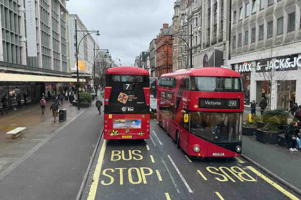
    Double-Decker rides in London; Route 7 & 390: Excellent for exploring Oxford Street, Regent Street, Hyde Park, and Camden.
    Route 7 & 390: Excellent for exploring Oxford Street, Regent Street, Hyde Park, and Camden.

    Why Ride a Double-Decker in London?

    1. It is Scenic and immersive:
    The upper deck provides unmatched views of London’s landmarks and street life. From famous monuments to hidden architectural gems, you’ll see far more than you would underground or on foot.

    2. It is budget-friendly sightseeing:
    A single bus fare costs just £1.75 with an Oyster card or contactless payment—no matter the distance. You can also transfer between buses for free within an hour thanks to the Hopper fare.

    3. It is Convenient and comprehensive:
    London’s bus network covers every corner of the city, often following scenic routes the Tube doesn’t. Many routes pass key attractions, neighborhoods, and shopping areas.


    Top Routes for Tourists

    While nearly any route can surprise you, several are especially scenic or useful for first-time visitors:

    • Route 11: From Liverpool Street to Fulham Town Hall, this line passes the Bank of England, St Paul’s Cathedral, Trafalgar Square, and the Houses of Parliament.
    • Route 9: Historic sights from Aldwych through Hyde Park and Kensington.
    • Route 15: Features heritage Routemaster buses on part of the route (check availability).
    • Route 7 & 390: Excellent for exploring Oxford Street, Regent Street, Hyde Park, and Camden.

    Practical Tips for the Best Experience

    Board smartly:
    Enter through the front door, tap your card, and head upstairs quickly for the best seats—front row, top deck.

    Travel off-peak:
    Try late mornings or early afternoons on weekdays to avoid rush hour and school crowds.

    Use the app:
    Download the TfL Go app or use Google Maps with public transport mode to plan routes, check arrival times, and navigate changes.

    Mind the curves:
    London’s narrow streets and tight corners mean you’ll feel every turn on the upper deck—hang on and enjoy the ride.

    Stay alert at landmarks:
    Use bus stops or upcoming announcements to time your photos. Many buses announce the next stop and highlight nearby attractions.


    Accessibility and Sustainability

    • Accessible travel: All modern London buses are step-free and equipped with designated areas for wheelchairs and strollers.
    • Green fleet: Many buses now run on electric or hydrogen power—like those seen on Route 7—supporting London’s ambitious emissions goals.

    Read more travel tips for Europe from my INDIVUE Visual travel guide for Europe!

  • The Spirit of Koli: A Majestic View Over Lake Pielinen

    *pr-trip with Visit Karelia Finland and Valamo Monastery

    Standing atop the rugged white quartzite cliffs of Ukko-Koli, one is met with a panorama that has stirred the souls of countless artists, poets, and travelers. The vast expanse of Lake Pielinen stretches into the horizon, dotted with forested islets and framed by the dark silhouettes of old-growth spruce. This view from Koli National Park, located in eastern Finland, is one of the most iconic and cherished landscapes in the country.

    With this image I captured a springtime moment in May, when random small piles of snow was still to be found from here and there on top of the Koli hill: you can see trees are still shaking off the last traces of winter, the lake glistens under a cloudy but bright sky, and the wind whispers through the evergreens. It’s a view immortalized in the paintings of Eero Järnefelt and cherished by Finnish national romantics for its raw, untamed beauty—a symbol of Finland’s soul.

    View from Ukko-Koli hill in Finland
    View from Ukko-Koli hill in Finland

    In this photo the rock is often the place where people go to have their selfies taken with Lake Pielinen, but me – after I had climbed on top of the Ukko-Koli hill, started feeling that much dizzy that I didn’t trust my legs, but stayed a bit further while concentrating on photography.

    Koli itself is more than just a scenic overlook, since for centuries, it has been a sacred site for the indigenous Karelians, used for slash-and-burn agriculture and pagan rituals. But today, it’s a beloved destination for hikers, nature lovers, and anyone seeking a deeper connection with Finland’s wild heart.

    Beneath the Pines of Koli: A Quiet Glimpse Over Lake Pielinen
    Beneath the Pines of Koli

    Beneath the Pines of Koli: A Quiet Glimpse Over Pielinen

    There are moments in nature when the world seems to pause—and this was one of them. I captured this photo beneath the sheltering branches of a weathered pine, and enjoyed this intimate view from Koli National Park revealing a more personal perspective of the iconic Lake Pielinen.

    Unlike the panoramic overlooks from Ukko-Koli, this scene feels tucked away, quiet, and reflective. It felt more safe standing there and photographing, watching the gnarled tree at the center, which clearly weathered many northern winters, its roots clinging to stone, its limbs stretching toward the glistening lake. Between the tree’s arms, the blue water spreaded out like a mosaic.

    The sunlight danced on pine needles and smooth granite rock, casting long, soft shadows. This was a place where you’re just far enough from the main trail to feel like the forest is yours alone — yet still connected to the grand, ancient rhythm of the landscape. And there was no one else in the forest to be seen.

    That was Koli at its most meditative: not a destination, but a moment.

    View from Koli towards East
    View from Koli towards East

    Light Over the Eastern Wilderness: Koli’s Forested Horizon

    As the sun filtered through the clouds above the forests of Koli National Park, rays of light streaked across the landscape like gentle brushstrokes on a vast green canvas. This view towards East offered a stunning contrast to the lake vistas Koli is famous for —revealing instead an endless expanse of forested hills, ridges, and distant lowlands. I could have watched this for hours.

    I captured this view in the soft light of late afternoon in all its layered majesty: Dark spruce trees stood tall in the foreground, their silhouettes sharp against the illuminated horizon. Here, the forest just doesn’t end—it simply continues, rolling quietly into the distance as far as the eye can see. Perhaps all the way to Russia.

    A Forest Campfire Spot in Koli
    A Forest Campfire Spot in Koli

    Rest and Refuel: A Forest Campfire Spot in Koli

    Tucked among the spruces and granite outcrops of Koli National Park lies a simple, yet inviting rest spot—a wooden bench circle with a covered campfire grill. It’s the kind of place that reminds you why Finland’s “Everyman’s Right” (jokamiehenoikeus) is so deeply cherished: nature is not only to be admired, but respectfully used and shared.

    This photo shows a designated campfire site common along Koli’s hiking trails. Set against a backdrop of towering trees and with glimpses of Lake Pielinen beyond, it offers the perfect mid-hike moment to pause, heat up a snack, or just sit quietly in the fresh forest air. The benches are crafted from sturdy timber, and the central fire pit is protected by a chimney-style hood to keep the smoke manageable and the fire safe.

    Such sites are maintained by Metsähallitus, Finland’s forest and park authority, and are part of a broader network of well-kept rest areas in national parks across the country. Visitors are free to use them, but always under the principles of low-impact hiking: clean up, respect fire restrictions, and leave the place better than you found it.

    Koli’s Welcome Sign to the Wilderness
    Koli’s Welcome Sign to the Wilderness

    At the Trailhead: Koli’s Welcome Sign to the Wilderness

    Before stepping into the ancient landscapes of Koli National Park, hikers are greeted by a set of information boards that serve as both a practical guide and an invitation to explore one of Finland’s most iconic natural treasures.

    These signs, posted near a popular trailhead, offer essential information for visitors. The first board introduces Koli’s history, its cultural and geological significance, and includes an artistic rendering of the view that has inspired generations of Finnish painters. Koli is not just a natural site—it’s a symbol of national identity and a sacred landscape in Finnish folklore.

    The central panel outlines the day hiking routes within the park, complete with a trail map, distances, and difficulty levels. From the short scenic walk to Ukko-Koli to longer circular routes like Mäkrän kierto or Kolin kierros, there’s something for every fitness level. Trails are marked clearly, and many start right from the Nature Centre Ukko, just uphill.

    The final board summarizes the rules of the park, a reminder of Finland’s respect-based relationship with nature. The “Hiker’s Etiquette” (Retkietiketti) covers topics like leaving no trace, staying on marked trails, and respecting wildlife. It’s a great snapshot of Finnish outdoor values: freedom to roam, balanced by personal responsibility.

    Eero Järnefelt’s Memorial on the Koli Trail
    Eero Järnefelt’s Memorial on the Koli Trail

    A Tribute in Stone: Eero Järnefelt’s Memorial on the Koli Trail

    Hidden among the rocks and mossy forest floor of Koli National Park lies a quiet, powerful tribute to one of Finland’s great painters—Eero Järnefelt (1863–1937). Mounted directly onto a natural rock face, this bronze relief portrait commemorates the artist whose work helped define the national romantic image of Koli and Finland itself.

    Eero Järnefelt was part of the Golden Age of Finnish art and a key figure in capturing the soul of the Finnish landscape. He visited Koli many times in the late 19th and early 20th centuries, often painting its sweeping lake views, forested hills, and atmospheric light. His work, alongside that of contemporaries like Akseli Gallen-Kallela and Jean Sibelius, helped elevate Koli into a symbol of Finnish identity.

    The memorial plaque is discreet, almost blending into the granite wall it adorns—just as Järnefelt sought not to dominate nature, but to understand and express it. The location, nestled in the forest and reached via a peaceful trail, offers a moment of stillness and reflection, surrounded by the very landscape he once painted. The painted landscape will also be soon visible in the Central Railway Station in Helsinki.

    Finding the Järnefelt Memorial

    • Location: Koli National Park, near the path between Ukko-Koli and Mäkränvaara
    • Memorial: Bronze relief plaque of Eero Järnefelt embedded in a cliffside
    • Trail Access:
      • Begin at the Koli Nature Centre Ukko
      • Slightly off the main path—keep an eye out on the cliff walls
    • Best Time to Visit: Spring through autumn; snow and ice may obscure the path in winter
    • Tip: Pause here and imagine the artist at work, brush in hand, translating this rugged landscape into eternal imagery
    On the Road to Koli
    On the Road to Koli

    Moment on the Road to Koli: Reflections by a Northern Lake

    As one travels through the rugged beauty of North Karelia, even the roadsides offer unexpected poetry. I captured this tranquil scene near the route leading to Koli National Park, where roadside lakes mirror the brooding sky above.

    The stillness of the water, disturbed only by a faint ripple or the flight of a distant bird, evokes the untouched serenity that defines this region.

    This image reminds travelers to pause—not just at famous viewpoints, but anywhere nature offers its quiet presence. The subtle beauty here isn’t marked by signs or crowds. It’s found in the way clouds drift across water, or how light breaks unexpectedly through heavy skies. These moments are as much a part of the Koli journey as the peaks themselves.


    How to Get There

    • Location: Koli National Park, Lieksa, North Karelia, Finland
    • Address for Navigation: Ylä-Kolintie 39, 83960 Koli, Finland
    • Getting There:
      • By car: Accessible via road from Joensuu (approx. 1-hour drive).
      • Public transport: Buses run from Joensuu to Koli village, especially during the summer season.
    • Entrance Fee: Free; parking may have a small fee in peak seasons.
    • Best Time to Visit: Year-round, but for panoramic views and hiking, May to October is ideal.
    • Facilities: Nature Centre Ukko offers exhibitions, maps, and a café. Marked trails lead to Ukko-Koli, Akka-Koli, and Paha-Koli viewpoints.

    Find more inspiring travel ideas for Finland from my visual online travel guide!

    INDIVUE – Trip to Finland – Visual travel guide